It seems to me that these few words from Josephus are the death-knell for those who insist on perpetuating the myth that the Jewish temples stood on so-called Temple Mount.
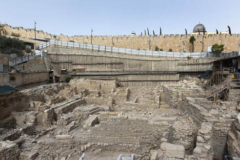
The Acra in the City of David has been identified in the excavations of the Givati Parking Lot, below the southern wall of the alleged Temple Mount. The excavation can be seen in the photo—and it can be seen to be well below and south and slightly west of the Mosque of Omar whose top can be seen. The Dome of the Rock is further north and west of the mosque and cannot be seen in this picture.
Josephus tells us that the Hasmoneans ‘took off part of the height of the Acra, and reduced it to be of less elevation than it was before, THAT THE TEMPLE MIGHT BE SUPERIOR TO IT.’
The Temple had to be south of this in the City of David as there is no way this Acra could be superior in height to a temple further up the hill.
The temple had been the dominant building in the City of David, but for a time this Acra or fortified compound, built by Antiochus Epiphanes, was slightly above it, until, as Josephus informs us, it was lowered so the temple remained superior to it (Josephus, War Book 5:136ff)
Josephus in the same place also tells us how they filled the Valley of the Cheesemakers or Tyropean which formed a division between upper (western) and lower (eastern) parts of the city, because they ‘had a mind to join the city to the temple’ (ibid 139).
Find details at the home page of how the site known throughout the Bible as HaMakom (The Place) came to be the site at which the temples stood. Read
'THE PLACE: HaMakom (where Jerusalem's temples stood)'
 RSS Feed